| Home | Issues & Actions | About |
Archive Page This page is available as an archive to previous versions of LandWatch websites. |
LandWatch and Common Ground Issue Joint Statement on Conservation and Development

| P.O.
Box 1369 Salinas, CA 93902 Phone: 831.771.1552 Fax: 831.771.1575 Email: info@commongroundmc.com Website: www.commongroundmc.com |
P.O.
Box 1876 |
February 7, 2002
David
Potter, Chair
Monterey County Board of Supervisors
240 Church Street
Salinas, CA 94901
RE: Principles To Guide Conservation and Development For Inclusion In The Monterey County General Plan Update
Dear Chairperson Potter and Members of the Board:
Both Common Ground Monterey County and LandWatch Monterey County believe that the County’s General Plan Update, now in process, offers our community an important opportunity to improve the land use policies that will guide the future growth and development of Monterey County. Both organizations believe that as growth occurs, it is important to phase and locate that growth in a way that conserves both important natural resource lands, and the commercially productive farmlands that are at the basis of the agricultural industry that sustains our local economy.
We also believe that our ability as a community to provide housing that is affordable to the essential workers who support the local economy can be improved by good land use policy decisions. We stand together for land use policies that are protective of our environment, promote a healthy and vital economy, and that respond to the concerns of social equity.
We jointly urge the Board of Supervisors of Monterey County to incorporate the conservation and development principles contained in the attached document into the new County General Plan Update. We realize that further work will need to be done, to implement these principles in a positive and effective way, but we think that these principles are an excellent and critically important "first step" towards sound land use policy. We are ready, both independently and collaboratively, to work on the "next steps," in cooperation with the Board and County staff.
Thank you for considering the conservation and development principles we jointly recommend.
Very truly yours,
| Sig
Christierson, President Common Ground Monterey County |
Keith
Vandevere, President LandWatch Monterey County |
Recommended
Principles For Conservation and Development
Common Ground Monterey County
LandWatch Monterey County
Introduction:
The future growth and development of Monterey County should be proactively
planned. Key issues are where and how growth should be directed,
and how rural and resource rich areas of Monterey County should
be conserved.
This joint statement by Common Ground Monterey County and LandWatch Monterey County outlines principles that both organizations believe should be incorporated into the Monterey County General Plan Update (GPU), now scheduled for adoption by the Board of Supervisors sometime in 2002.
Conservation
Principles:
Many areas of Monterey County are physically constrained for development
and are either not suitable for intensified growth and/or contain
contiguous, high value species habitat and ecosystems. These areas
are typically steep and too remote to support increased densities
of development. In addition to their habitat value, these areas
also frequently serve as watersheds and recharge zones for local
aquifers. A significant segment of the population is concerned that
the widespread urbanization that has occurred in other areas in
California could occur in the rural, resource rich areas of Monterey
County.
Given the County’s large landmass with its unique and diverse ecosystems, Common Ground and LandWatch agree that there are large areas within the County that are appropriate for conservation. Both organizations also agree that there is a need to conserve these areas, and that conservation areas should be proactively planned. LandWatch and Common Ground concur with the large-scale approach used by The Nature Conservancy (TNC) to ensure the viability of contiguous ecosystems and species habitats.
The County should ensure the conservation and protection of identified conservation areas, and creative incentives and well-planned conservation techniques now being used by conservancies and land trusts throughout the State should be positively supported and built into the new General Plan. While some limited development will undoubtedly occur within conservation areas, LandWatch and Common Ground strongly believe that these are not areas where new development should be encouraged, and that within identified conservation areas, Monterey County should undertake active measures to discourage development. The County should, however, allow for the following development activities expected to occur within such identified conservation areas, subject to site specific development standards, in order to ensure the continued economic viability of the underlying land uses, and to achieve conservation objectives:
- Acknowledging viable uses on existing lots of record
- Some agricultural and recreational uses, including grazing operations that are consistent with current grazing designations
- Customary accessory uses
- Some resource dependent uses
- Court ordered subdivisions
In addition to the above, within identified conservation areas, Monterey County should permit lot line adjustments, subdivisions for estate planning and financing, the creation of new parcels, density bonuses where appropriate, and the clustering, and reorganization, and resubdivision of existing parcels and/or lots of record that will achieve one or more of the following:
- Clustered
development that transfers or reduces the actual potential for
development on existing parcels and/or lots of record, and that
achieves greater permanent conservation and habitat protection
than could be achieved without such development. Examples include
clustering parcels next to infrastructure such as roads and water
supplies thereby reducing grading, erosion, splitting habitats,
wells, driveways, etc.
-
The creation of large, contiguous agriculturally viable parcels
from fractured smaller parcels, especially when coupled with the
creation of agricultural easements or the application of other
techniques to provide permanent protection for viable agricultural
lands, including grazing lands, and to support the economic viability
of the county’s agricultural industry, including grazing.
-
The creation of suitable donor and recipient parcels for the transfer
of development credits, when the transfer achieves greater permanent
conservation and habitat protection than could be achieved without
such development.
-
Density transfers to more suitable building areas both within
and outside identified conservation areas, when the density transfer
achieves greater permanent conservation and habitat protection
than could be achieved without such development.
-
The creation of larger parcels from a series of smaller parcels
and/or lots of record for transfer/sale/donation to conservation
groups.
-
The creation of larger parcels from a series of smaller parcels
and/or lots of record for transfer/sale/donation to a federal,
state, or local agency for parks, open space, or conservation
purposes.
-
The creation of a larger parcel from a series of smaller parcels
and/or lots of record where the new parcel has a high concentration
of sensitive habitats, and the creation of the parcel results
in greater permanent conservation and habitat protection than
could be achieved without such development.
-
The creation of a new parcel that could be sold to generate income
for the purchase of resource-rich/sensitive lands, when the creation
of the new parcel will demonstrably result in greater permanent
conservation and habitat protection than could be achieved without
such development.
-
The creation of a new parcel that could be used for conservation
banking, when the creation of the new parcel will demonstrably
result in greater permanent conservation and habitat protection
than could be achieved without such development.
- Similar win-win conservation efforts.
Development
Principles:
Common Ground Monterey County and LandWatch Monterey County strongly
urge Monterey County and each one of the cities in Monterey County
to coordinate their General Plans to achieve a countywide plan to
accommodate future growth and development.
The future growth and development of the County should be directed, compact, and phased, and should be planned with desirable long-term growth patterns in mind. A priority for future growth and development should be for infill into existing urban areas that include:
- The existing City limits of all Monterey County cities;
- The unincorporated areas of Pajaro, Castroville and Boronda, within the existing redevelopment areas;
- The County lands on the former Fort Ord.
In order to accomplish infill, it is imperative that the cities and the County adopt aggressive, incentive driven infill plans to ensure that infill is economically feasible and viable. City Housing Elements should include robust incentives for infill, including:
- General
Plan and zoning designations that support mixed uses and higher
densities including, but not limited to:
- Density bonuses (in addition to State mandated bonuses)
- Higher densities/minimum density requirements
- Reduced setbacks
- Modified height limits
- Reduced parking restrictions
- Appropriate design guidelines
- Upgraded
building codes as needed to support general plan and zoning incentives
for infill.
- Local
government facilitation of parcel assembly for multiple infill
parcels including: City land acquisition programs and incentives
for lot merger programs.
-
Fast tracking/priority processing for infill projects (designated
planners, CEQA exemptions, other).
- Revenue
incentives for infill development including:
- Revenue bonds for infill development.
- Redevelopment fees allocated to infill development.
- Reduced or waived fees for infill development (e.g. reduced processing fees and reduced/waived open space, transit, affordable housing, other fees based on type and location of project).
- Higher fees and "mitigation" fees for non-infill projects to discourage such growth and reflect higher "costs" to the community, in terms of both service/infrastructure costs and loss of prime agricultural and open space lands.
Other incentives that should be considered include: public awards for innovative developments; programs to raise awareness for the importance/benefits to the community of infill type projects; provision of city garages; and enabling legislation for land trusts.
Realizing that during the next twenty year planning period growth may well occur beyond the amount that will be accommodated in existing urban areas and on existing lots of record, LandWatch and Common Ground agree that such future growth and development should be accommodated by annexations adjacent to existing cities. Such annexations should proceed only after respective cities have infill incentive programs in place.
In both "infill" and "expansion" areas, growth and development should proceed according to the following principles:
- The
design should create compact, mixed-use neighborhoods, in which
different income levels and land uses are appropriately combined.
Such neighborhoods should be based on one or more community "hubs,"
such as residential, commercial, professional, institutional,
and other appropriate land uses, rather than being constructed
as pure residential subdivisions.
-
The design should meet a community need. Specifically, the County
and cities should promote density and design concepts that will
increase the amount of housing that is affordable to the full
range of Monterey County’s workforce, and should strive to
achieve a job and housing balance in all areas of the County.
- The
design should promote a style consistent with the existing and
historical character of the community in which the development
occurs.
-
The design should promote the efficient use of land and resource
sustainability.
-
The design should include a full range of very low, low, workforce,
and higher-income housing. Both incentives and requirements should
be considered to achieve housing goals, including, but not limited
to: housing trust fund, linkage fees, inclusionary requirements,
density bonuses beyond State law, fee incentives, etc.
- The
design should be pedestrian oriented, and promote transit and
carpools.
- The
design should promote the redevelopment and reuse of existing
urban areas, and the recycling of urban resources.
- Infrastructure and public services (e.g. water, transportation, schools, law enforcement, fire, emergency services, etc.) should be sufficient to accommodate both existing and new development at acceptable service levels. The County and cities should coordinate their respective long-term planning and capital improvement programs so this objective can be achieved and lack of services will not be an impediment to planned growth.
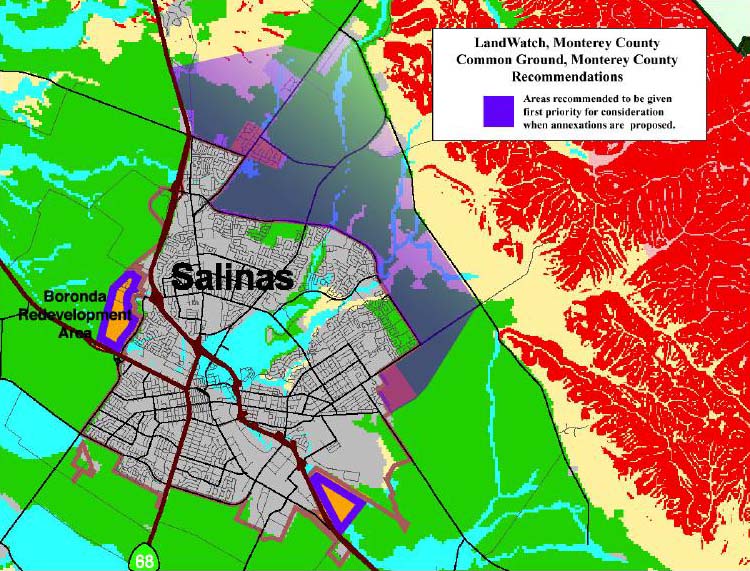
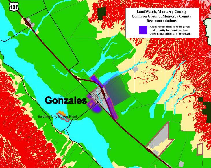
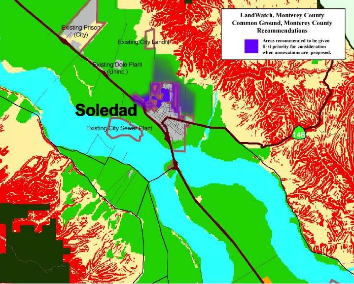
Cities that have infill programs in place can be expected to propose annexations to accommodate additional growth during the twenty-year planning period. Those areas indicated on the attached maps include more than sufficient land to accommodate development over the next twenty years, and should be given first priority for consideration when such annexations are proposed, within the framework of the other principles contained in this document.
I. Carmel II. Del Rey Oaks III. Fort Ord (FORA Plan) IV. Gonzales V. Greenfield VI. King City VII. Marina VIII. Monterey IX. Pacific Grove X. Salinas XI. Sand City XII. Seaside XIII. Soledad
Common Ground and LandWatch agree that programs should be adopted to conserve commercially productive agricultural land. Planning tools, incentives and other techniques, such as those listed below, should be used to provide long-term conservation for the most valuable agricultural lands surrounding the cities, in areas where future growth and development is not desired (see maps):
- Implementation
of Williamson Act programs, including, but not limited to "Super
Williamson Act," and Williamson Act exchange program.
-
Enforcement of right to farm ordinance(s).
-
Provisions for adequate support services for agriculture (e.g.
adequate and appropriately designated/zoned land for agricultural
uses including processing, packaging, shipping, etc., and transportation
systems for movement of goods).
-
Voluntary conservation easement purchase programs.
- Other support programs for local agriculture, including Local Grown programs (e.g. Sonoma Select) and technical assistance, and agricultural loan programs.
Maps:
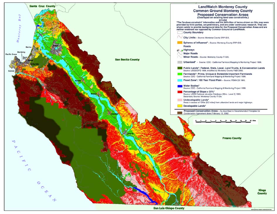
The first map attached to the Joint
Statement of Conservation and Development Principles shows areas
(in brown) where both LandWatch and Common Ground believe that the
"Conservation Principles" should be applied. This map
was prepared on a basemap that included information from the Monterey
County GIS mapping program. Areas specifically designated for conservation
are based on recommendations from The Nature Conservancy.
County Map (168K)
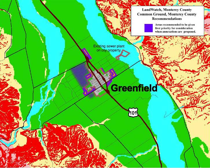
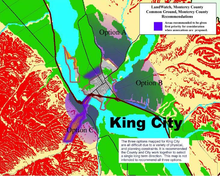
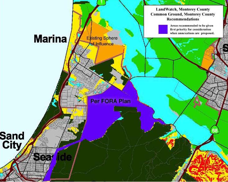
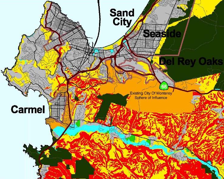
The other maps attached to the Joint Statement of Conservation and Development Principles are maps of the Salinas area, the Gonzales area, the Soledad area, the Greenfield area, the King City area, the Marina and Sand City area, and the Monterey Peninsula area. These maps show (in purple) areas that are to be given first priority for consideration when annexations are proposed to cities.
Salinas area map (166K)
Gonzales area map (166K)
Soledad area map (148K)
Greenfield area map (152K)
King City area map (175K)
Marina and Sand City area map (123K)
Monterey Peninsula area map (181K)
The following language from the Joint Statement of Conservation and Development Principles explains how LandWatch and Common Ground expect these maps to be used:
Cities that have infill programs in place can be expected to propose annexations to accommodate additional growth during the twenty-year planning period. Those areas indicated on the attached maps include more than sufficient land to accommodate development over the next twenty years, and should be given first priority for consideration when such annexations are proposed, within the framework of the other principles contained in this document [emphasis added].
02/15/02
|
CONTACT 306 Capitol Street #101 PO Box 1876 Phone (831) 759-2824 Fax (831) 759-2825 |
|